These days it is mainly a tourist attraction, but Bruges was once an international world city, like London or Shanghai. The reason? Its many outer ports in the Zwin channel. New archaeological, historical and geological research has now made it possible to reconstruct that past in an unprecedented manner.
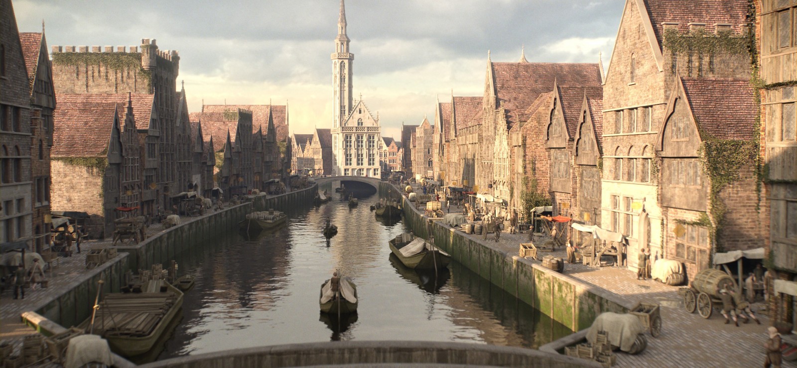
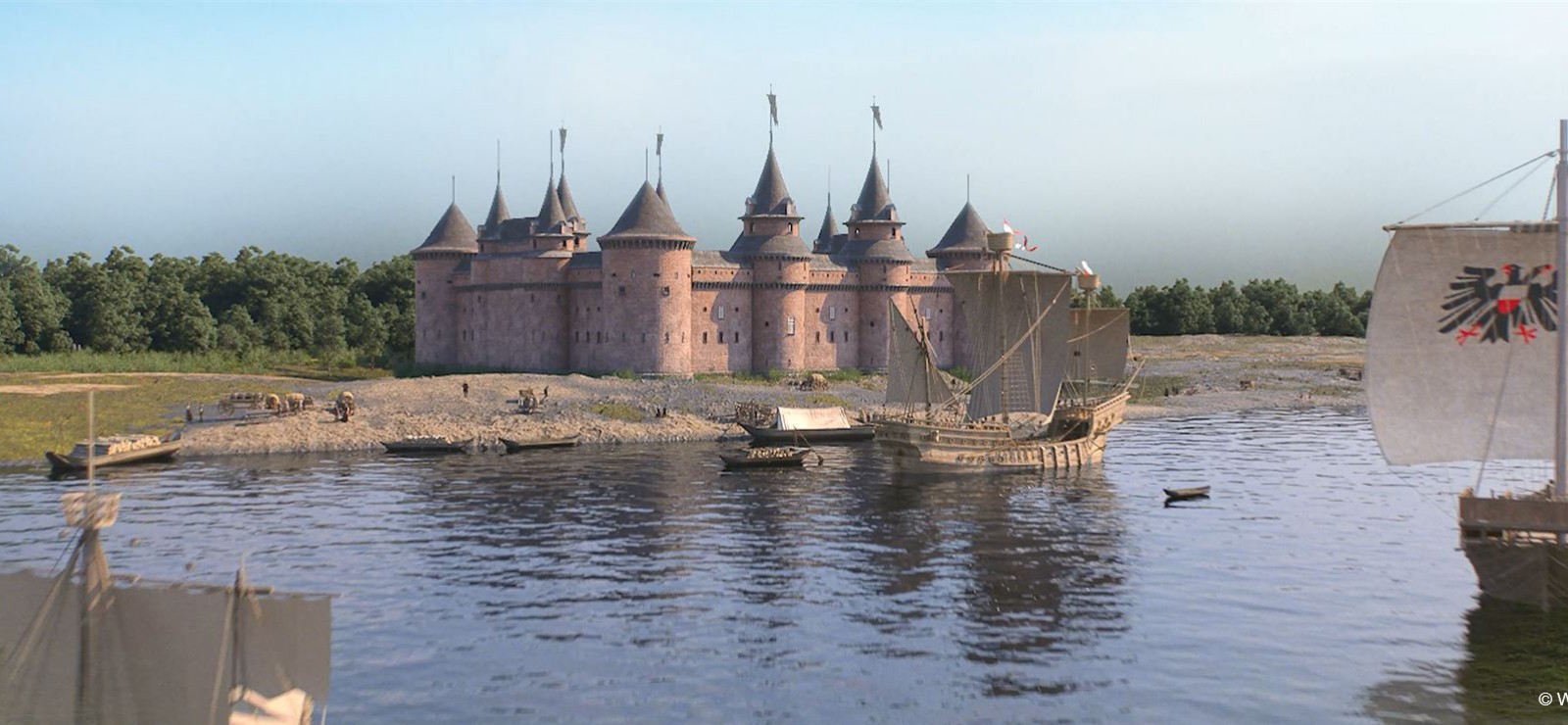
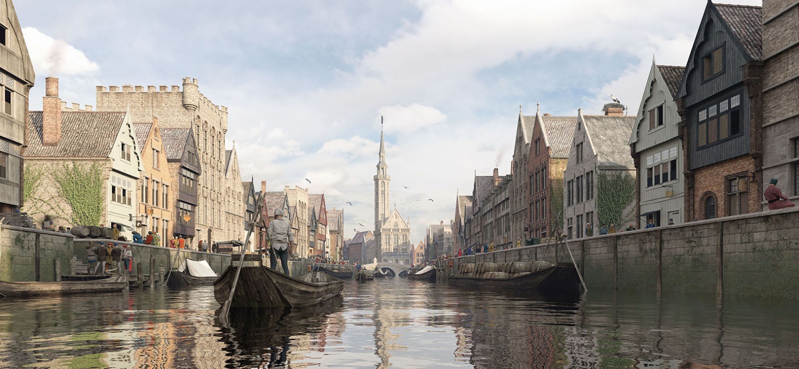
You can take the word reconstruction quite literally. At least in visual terms. Indeed, thanks to an intensive partnership with illustrators, researchers have brought the port cities ‘back to life’ in 3-D. Medieval Damme and Sluis have been drawn in detail, and also Bruges has been revealed in a way that is almost photorealist. All of our present knowledge about buildings, streets, location and so on has been visualised as correctly as possible. Even the long-lost port town of Monnikerede has been entirely revived.
Archaeology without the digging
The town just referred to was only a stone’s throw from Damme, somewhere near what is now the Damme Canal. So did researchers churn up the whole polder district of around 20 kilometres to get to the bottom of this? Not at all: “The Zwin ports have been mapped out without excavation and with non-invasive research by Jan Trachet, as part of his postdoctoral research”, says professor Wim De Clercq from the department of Archaeology at Ghent University.
You can spot ‘tell-tale signs’ in the landscape, for example, with aerial photography. In fact much material is literally there for the taking: “When you plough fields, you find all kinds of things. Using the research method known as field walking, we cover the field and record the coordinates of our findings with a GPS. We can estimate the approximate age of each fragment. Once you plot all the sites of your findings on a geographical ‘map’, clusters begin to emerge. Then, for example, you find a zone with only material from the 13th century, another zone with fragments from the 15th century, …”
Tipped off by the moles
You can also take a good look in the ground without digging, thanks to geophysical ground research: “EMI scans are used to measure things such as the magnetic conductivity of a specific soil volume. A wall made of baked clay contains iron minerals, and is therefore magnetic. This is not the case with the clay soil beside it. The scans measure the differences. In this way, you discover whether a building is located under the ground, or the course of a road and so on. This means that, as archaeologists, we do not always need to resort to digging.”
On top of that, there is an unexpected partner in crime when it comes to soil investigation: the mole. “Much of the port zone is meadow land, and there are hundreds of molehills. Students sieved this earth and identified their findings: the number of stones, nails, bones, fragments, … The interesting thing about moles is that they end up in places where houses once stood. After all, such places have plenty of organic waste in the soil, which is where you’ll find the worms. Is there a hidden road? Then you suddenly see lots more little stones emerge in the molehills in that particular area.”
Virtual Reality
Diverse sources are combined in order to visualise the small towns. Wim De Clercq: “We link archaeological research and geophysical ground scans with historical research from maps and written sources. From the texts we gain information about who lived on the particular plot, the type of house and the size of the plot. We then chart the archaeological findings to identify the kind of activities that were performed there.”
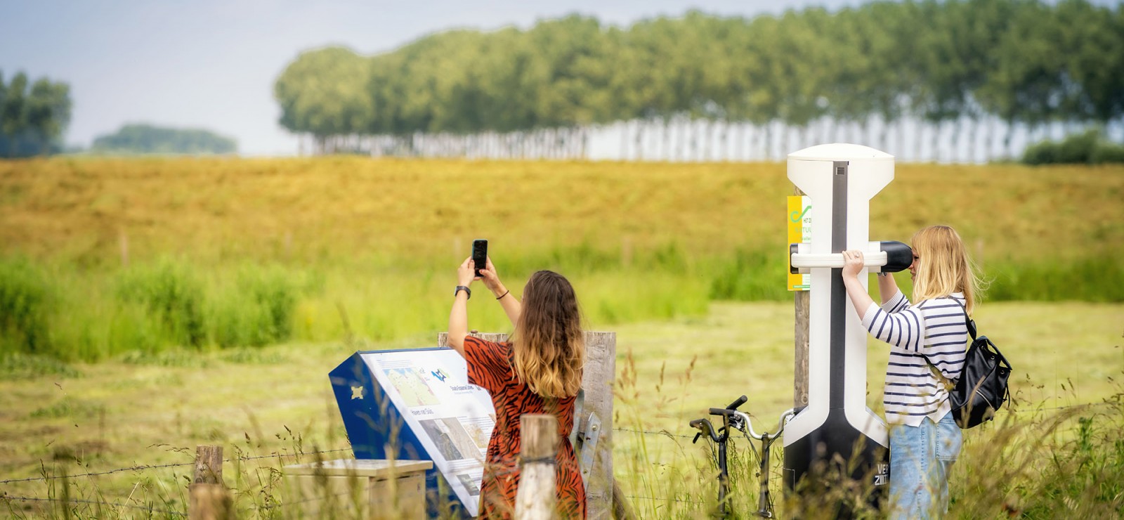
This is used to create a map of the town, and we continue by reconstructing each house in more detail. A painstaking procedure, involving many months of intensive collaboration. To give you an idea: work to create the 3-D visualisations of Monnikerede and Sluis Castle took several researchers and illustrators six months of intensive teamwork. The result is incredible. Better still, as from July, you can discover it for yourself with the help of Virtual Reality glasses along cycle routes in the polders, as part of the exhibition ‘The Lost Zwin Ports’.
Deforestation
Something you certainly won’t spot in the 3-D visualisations is trees. “Back then the area had been almost entirely deforested”, explains Wim De Clercq. “Never before had so many people lived so close together in an urban environment. They worked as traders, in the ports and in all kinds of port-related industries. Today, Hoeke is a small village, but in those days it was a shipyard. We know that because we pinpointed a number of forges. The region’s energy requirements were so huge that the impact on nature was immense. Coal was even imported from England. It was the first time in the history of Flanders that such an energy-intensive system was established.”
The research began back in 2012. It has a number of objectives, including charting the Zwin ports, and also the trading transactions in Bruges. In the past historians have tended to focus on the trading of luxury goods, but in fact the majority of trade was simply bulk items, such as wood or ore. “We know so little about this”, says historian Elisa Bonduel, who is devoting her doctorate to source research about such trading.
Elisa also aims to find out how important Bruges was as a transit port to the Flemish hinterland. “I want to know whether goods were transferred to smaller ships in the Zwin region, for further distribution across Flanders. Was the Zwin the gateway for bulk products brought to Flanders via the sea? Or did the river Scheldt play a more important role? For the moment, this local trading is still a black hole when I look at the available archive material.”
Luxurious plate
One thing’s for sure: the region was awash with traders from all over Europe. That is also revealed by the material findings in and around the outer ports. Archaeologist Maxime Poulain: “Foreign merchants came to Bruges and the Zwin ports with trading goods, and stayed there in colonies. Just think of the German trading association De Hanze. Italians and Spaniards stayed in the area, we know that for sure.”
Maxime also warns against focusing too much on luxury in late-medieval Bruges: “With my research into the material culture in the 12th to 15th century I am trying above all to make an inventory of everyday items, in order to gain a better understanding of the trading paths and quantities. Something fun about the Zwin district is that luxury products, such as pottery from Valencia, are found everywhere, which includes households where you wouldn’t expect it. It is likely that the sailors guiding the foreign merchants through the Zwin channel took payment in kind. This richer material culture might point towards a certain prosperity. Yet the fact you have a luxurious plate does not necessarily mean you can magic enough food onto the table. Not everyone benefited from the economic wonder in Bruges.”
Why is this research so important, according to Wim De Clercq? “As well as being a tourist attraction, Bruges is also UNESCO world heritage. We often fail to realise the international importance of our past and patrimony. It’s fine to be chauvinistic once in a while. That’s why we’re delighted with the opportunity offered by these new techniques and visualisations for a wide audience to experience one of Europe’s very first large metropolises. Plus get a sense of its relativity: how Bruges emerged, but also the city’s demise.”
Bruges, Damme, Monnikerede, Hoeke, Sint-Anna-ter Muiden and Sluis were once the greatest ports in Europe. However, the Zwin channel silted up and the ports disappeared. A cycle route with VR viewers and experience exhibition in the Zwin Nature Park bring the medieval Zwin ports back to life as from 3 July.
The exhibition lasts from 3 July to 7 November 2021, the cycle route from 3 July 2021 to October 2023.
(images: Westtoer)
Read also
Three new Stolpersteine in Ghent: the tragic story of Rifca, Valère and Falks
Around thirty Stolpersteine can be found in the sidewalks across Ghent. On November 5th, three more were added for Ghent University victims Valère, Falks, and Rifca.

Judith or not? In search of the first Countess of Flanders
TV show Het verhaal van Vlaanderen was certain: the box just unearthed from the City of Ghent's heritage depot contained the remains of the one and only Judith, the progenitor of the Counts of Flanders. But was that really true?

A ‘tree’mendous tale of natural resilience
What if trees could talk? Well, every so often they do. In doing so, they give a glimpse of the past. For example, a 250-year-old oak in the castle grounds at Elverdinge near Ypres tells us more about the First World War. The tree survived this war, despite the incessant bombs. The Woodlab at Ghent University tells us the touching story of this oak tree.

Stonehenge reveals traces of a much older past
A particularly valuable discovery has turned our knowledge of Stonehenge upside down. On the most researched site in the world, a research group including a few Ghent University students has found traces that are much older than anything that has been excavated so far. We know that there are still secrets to be uncovered from bio-engineer Philippe De Smedt, among other things thanks to soil scans.
